Bill's Nova Scotia Radio Site
HALIFAX REGIONAL FIRE AND EMERGENCY
SERVICE
last updated July 31, 2014
General
Halifax Regional Fire is the largest fire department in geographical extent in all of eastern Canada, and in terms of personnel and equipment is certainly the largest east of Quebec City. It is divided into a core area (Stations 2 to 18) covering the urban and suburban areas of Halifax proper, Dartmouth, Bedford, Sackville, Cole Harbour and Eastern Passage, and a much larger rural area (Stations 19 to 65) lying to the west and east of the core. All units operate on the same set of radio channels, so that urban units can assist at urban incidents and (more rarely) vice versa.
HRFE dispatching is integrated with that for the police services of HRM, and is located in Dartmouth at the Eric Spicer building. This centre also operates the 911 call-taking service for HRM and together the whole operation is called IES (Integrated Emergency Service). While the operators can move between these functions, the three services are physically separated in the one large room. The centre uses TMRS consoles and can send all pages and communications directly to distant TMRS towers via fibre optics.
Paging and Stations
See the chart below for a list of stations.
Paging for HRM Fire Service is normally takes place on 9 VHF frequencies indicated on the chart below. Two of the frequencies are used for the core Halifax/Dartmouth area. Seven other frequencies are used in the rural areas, with some of these are in use at multiple locations.
Use of the VHF paging frequencies is entirely for paging. All two way communications are on the NS Trunked Mobile Radio System (TMR1).
There is a backup system on conventional 800 MHz as shown in the communications chart depicted farther down this page. Pages are transmitted on 800 MHz from time to time for test purposes.
Anyone not wanting to read the details can simply program the VHF frequencies into their scanners, and will hear (subject to the limitations of their location and antenna) practically all pages for HRM and also for Mt Uniacke and Enfield in Hants County. This reception is of course subject to location. For example listeners in the Halifax core area will not likely hear pages transmitted in the far eastern areas of HRM.
Operations on operations channel DISP-C are repeated (simulcast) on rural page transmitters, so that volunteers equipped only with pagers can follow the first stages of a call-out. Once sufficient personnel arrive on scene, operations move to another talk group and these are NOT simulcast on the page frequency.
The backup 800 MHz frequencies may also be entered into your scanner, but don't expect much activity.
Note also that HRM pages the CCGC Sambro, at least in its crew's off hours. While the nature of the incident may be mentioned, the crew is merely requested to contact the JRCC (Joint Rescue Coordination Centre) in Halifax for details and tasking, and there is no two-way communications with the cutter. Some of the frequencies are in use at multiple locations.
Further comments re pages:
While there is a back-up paging system on 800 MHz it is unknown how it would actually be used, due to the fact that individual firefighters do not have 800 MHz paging receivers.
Official lists of frequencies found in Industry Canada's TAFL site show 154.65 as a paging frequency; however in each case the site shown as having 154.65 actually is using 152.06 MHz, which is not listed for HRFE in TAFL in any location.
It is unknown why some frequencies such as 152.06 are used in two or three locations, whereas 154.415 and 154.175 are each used in only one location. There are areas such as along the eastern shore near Ship Harbour where all three pagers on 152.06 can be easily heard which is something that an observer might think should not be happening if there are other frequencies available. Conversely it might be said that there seems to be little need for a separate frequency of 154.175 for Ecum Secum when one of the others such as 153.89 would work as well. There are no other users of 153.89 in that area and therefore to the casual listener such as this one, it is a conundrum for sure. A related observation is that in some other parts of Nova Scotia, all the pagers are on one single frequency, rather than several. One has to ponder the relative effectiveness and cost of such options.
|
Station and Paging Details Note that a number of stations have been closed since the establishment of the integrated fire service, with the largest number of closures at one time occurring in late 2013, due to low usage and more particularly, the lack of volunteers. Core stations are manned entirely by paid personnel. Hybrid stations have two paid personnel during weekdays daytime hours, but rely on volunteers for augmentation, and for all services at other times. Volunteer stations are entirely that. Rural station call-outs are routinely backed up by call-outs of adjacent stations and it is not unusual for a backup unit to be the first to arrive on scene, this being due to lack of immediate volunteers at the local station.
July 2014 Note: A plan was announced to modify the hybrid station manning scheme, ostensibly temporarily and to expire on October 31, to accommodate vacation time for career firefighters. This scheme will see the following hybrid stations "temporarily" lose the daytime paid coverage and therefore become volunteer only: Seabright, Black Point, Harrietsfield/Sambro, Goffs, Chezzetcook and Lawrencetown. In order to compensate for what amounts to a reduction of coverage, other hybrid stations in nearby areas will receive enhanced paid manning that results in a total of four firefighters for 10.5 hours on weekdays for each of the following: Upper Tantallon, Sambro, Herring Cove, Shad Bay, Hammonds Plains, Fall River, Middle Musquodoboit, Musquodoboit Harbour and Lake Echo.
|
| STATION # | Zone | LOCATION | Freq | CAP
CODE(S) (to convert codes to tones click here) |
Pager Location |
| Stn 1 | Alderney Gate, Dartmouth (Headquarters, not a working station) | - | |||
| Stn 2 | CORE |
University Avenue, Halifax |
151.4 | Station Page only, CAP unknown | Lively Road, Middle Sackville* |
| Stn 3 | CORE |
West Street, Halifax |
151.4 | Station Page only, CAP unknown | Lively Road, Middle Sackville |
| Stn 4 | CORE | Lady Hammond Road, Halifax | 151.4 | Station Page only, CAP unknown | Lively Road, Middle Sackville |
| Stn 5 | CORE |
Bayers Road, Halifax |
151.4 | Station Page only, CAP unknown | Lively Road, Middle Sackville |
| Stn 6 | CORE | Spryfield, Halifax | 151.4 | Station Page only, CAP unknown | Lively Road, Middle Sackville |
| Stn 7 | CORE |
Knightsridge |
151.4 | Station Page only, CAP unknown | Lively Road, Middle Sackville |
| Stn 8 | CORE | Bedford | 151.4 | Stn ?,Volunteers 575, Zone 590 | Lively Road, Middle Sackville |
| Stn 9 | CORE | Metropolitan (Lr. Sackville) | 151.4 | Stn ?,Volunteers 550, Zone 590 | Lively Road, Middle Sackville |
| Stn 10 | CORE | Millwood (Middle Sackville) | 151.4 | Lively Road, Middle Sackville | |
| Stn 11 | CORE | Patton Rd, Upper Sackville (this station typically has light use compared to other core stations) | 151.4 | Lively Road, Middle Sackville | |
| Stn 12 | CORE | Highfield Park Dartmouth | 152.18 | Station Page only, CAP unknown | Preston, but see below** |
| Stn 13: | CORE |
King Street, Dartmouth |
152.18 | Station Page only, CAP unknown | see below |
| Stn 14 | CORE |
Westphal, Dartmouth |
152.18 | Station Page only, CAP unknown | see below |
| Stn 15 | CORE |
Pleasant Street, Dartmouth |
152.18 | Station Page only, CAP unknown | see below |
| Stn 16 | CORE | Eastern Passage | 152.18 | Stn ?,Volunteers 540, Zone 590 | see below |
| Stn 17 | CORE | Cole Hbr Road | 152.18 | Stn ?,Volunteers 505, Zone 590 | see below |
| Stn 18 | CORE | Main Street | 152.18 | see below | |
| Stn 19 | Rural Zone 1 | West Lawrencetown | 153.89 | 595, Zone 520
|
Preston |
| Stn 20 | Rural Zone 1 | Lawrencetown | 153.89 | Preston | |
| Stn 21 | Rural Zone 1 | Lake Echo | 153.89 | 580 Zone 520 | Preston |
| Stn 22 | Rural Zone 1 | North Preston | 153.89 | Preston | |
| Stn 23 | Rural Zone 1 | Chezzetcook | 151.505 | 575, Zone 520 | Musquodoboit Hbr |
| Stn 24 | Rural Zone 1 | Musquodoboit Harbour | 151.505 | 560, Zone 520 | Musquodoboit Hbr |
| Stn 25 | Rural Zone 1 | Ostrea Lake | 151.505 | 510, Zone 520 | Musquodoboit Hbr |
| Stn 26 | Rural Zone 1 | Oyster Pond | 152.06 | 530, Zone 52 | Beech Hill |
| Stn 27 | Rural Zone 1 | Owls Head [THIS STATION WAS CLOSED IN THE EARLY 2000'S] | |||
| Stn 28 | Rural Zone 2 | Sheet Harbour | 154.28 | 640, Zone 639 | Sheet Hbr CBC Tower |
| Stn 29 | Rural Zone 2 | Moser River | 154.175 | 635, Zone 639 | Ecum Secum TMR site |
| Stn 30 | Rural Zone 2 | Tangier | 154.13 | 636, Zone 639 | Tangier |
| Stn 31 | Rural Zone 2 | East Ship Harbour (Substation to Tangier) | 154.13 | Tangier | |
| Stn 32 | Rural Zone 2 | Mooseland [THIS STATION WAS CLOSED IN THE FALL OF 2013] | |||
| Stn 33 | Rural Zone 2 | Three Harbours | 154.28 | 637, Zone 639 | Sheet Hbr CBC Tower with a delayed store and forward (echo) page on the same frequency from a site near Port Dufferin |
| Stn 34 | Rural Zone 2 | Mushaboom | 154.28 | 610, Zone 639 | Sheet Hbr CBC Tower |
| Stn 35 | Rural Zone 3 | Cook's Brook | 154.13 | 602, Zone 620 | Chaswood |
| Stn 36 | Rural Zone 3 | Meagher's Grant | 154.13 | 671, Zone 620 | Chaswood |
| Stn 37 | Rural Zone 3 | Elderbank (substation to Meagher's Grant) [THIS STATION WAS CLOSED IN THE FALL OF 2013] | |||
| Stn 38 | Rural Zone 3 | Middle Musquodoboit | 154.13 | 634, Zone 620 | Chaswood |
| Stn 39 | Rural Zone 3 | Upper Musquodoboit | 152.06 | 693, Zone 620 | Upper Musquodoboit |
| Stn 40 | Rural Zone 3 | Dutch Settlement | 154.28 | 638, Zone 620 | Shubenacadie TMR site |
| Stn 41 | Rural Zone 4 | Waverley | 154.415 | 390, Zone 360 | Lively Road, Middle Sackville |
| Stn 42 | Rural Zone 4 | Wellington | 154.415 | 305, Zone 360 | Lively Road, Middle Sackville |
| Stn 43 | Rural Zone 4 | Grand Lake | 154.415 | 370, Zone 360 | Lively Road, Middle Sackville |
| Stn 44 | Rural Zone 4 | Windsor Junction [This station was closed and consolidated with 45 in the early 2000's or earlier] | |||
| Stn 45 | Rural Zone 4 | Fall River | 154.415 | 395, Zone 360 | Lively Road, Middle Sackville |
| Stn 46 | Rural Zone 4 | Lakeview [This station was closed and consolidated with 45 in the early 2000's or before] | |||
| Stn 47 | Rural Zone 4 | Goffs | 154.415 | 375, Zone 360 | Lively Road, Middle Sackville |
| Stn 48 | Rural Zone 4 | Beaver Bank - Kinsac (this station number was formerly used by the North Beaver Bank station at Beaver Bank Villa... Number transferred to the consolidated station opened at Kinsac Road) | 154.415 | 350, Zone 360 | Lively Road, Middle Sackville |
| Stn 49 | Rural Zone 4 | Kinsac [this station was closed when the relocated Station 48 was opened in the mid 2000's] | |||
| Stn 50 | Rural Western Region | Hammonds Plains | 152.06 | 260, Zone 230 | Hammonds Plains |
| Stn 51 | Rural Western Region | Upper Hammonds Plains [THIS STATION WAS CLOSED IN THE FALL OF 2013] | |||
| Stn 52 | Rural Western Region | Hatchet Lake | 154.28 | 240, Zone 230 | Prospect |
| Stn 53 | Rural Western Region | Terrance Bay [THIS STATION WAS CLOSED IN THE FALL OF 2013] | |||
| Stn 54 | Rural Western Region | Shad Bay | 154.28 | Prospect | |
| Stn 55 | Rural Western Region | Seabright | 153.89 | 275, Zone 230 | Queensland |
| Stn 56 | Rural Western Region | Black Point | 153.89 | 205, Zone 230 | Queensland |
| Stn 57 | Rural Western Region | St. Margarets [this station was closed when Station 65 was opened in or around 2010] | |||
| Stn 58 | Rural Western Region | Lakeside | 152.06 | 290, Zone 230 | Hammonds Plains |
| Stn 59 | Rural Western Region | Bay Road [this station was closed when Station 65 was opened in or around 2010] | |||
| Stn 60 | Rural Western Region | Herring Cove | 154.13 | 295, Zone 230 | Harrietsfield |
| Stn 61 | Rural Western Region | Ketch Harbour [THIS STATION WAS CLOSED IN THE FALL OF 2013] | |||
| Stn 62 | Rural Western Region | Harrietsfield | 154.13 | 280, Zone 230 | Harrietsfield |
| Stn 63 | Rural Western Region | Sambro | |||
| Stn 64 | - | There is no Station 64, and to this point never has been. | |||
| Stn 65 | Upper Tantallon (This station was built to replace Stations 57 and 59) | 152.06 |
??, Zone 230 (Station tone might be 250) |
Hammonds Plains | |
| Non-HRM stations dispatched by HRM | |||||
| Enfield VFD | 154.28 | ? | Shubenacadie TMR site | ||
| Mount Uniacke VFD | 154.415 | 380, Zone 360 | Lively Road, Middle Sackville, with an delayed echo xmtr same frequency near Mt Uniacke | ||
| Hubbards VFD (This department was formerly dispatched by HRFE but has reverted to dispatch by Scotia Business Centre, using 154.25 MHz) | ? |
||||
| Coast Guard Cutter Sambro | 154.13 | Harrietsfield | |||
* 151.4 may be transmitted from an additional site in the core area to better serve the downtown stations (verification needed)
**The 152.18 pager has been stated to be at Preston but TAFL indicates 152.18 is in downtown Halifax.
Rural Details: The rural area is divided into 6 Emergency Response Zones; however Zone 5 (formerly Zones 5 and 6) is normally referred to as the Western Region. The other zones are in the Eastern Region. Pageouts can be done by complete zone when necessary. Rural stations have their own station or department chiefs but are under the administration or or oversight of a career District Chief. Stations are paged via VHF in a two-stage or three-stage system. It is thought that the central dispatcher sends a page out to the appropriate TMRS tower and in some cases it is transmitted by VHF directly from that tower. In other cases it goes from the tower by UHF? signal to a non-TMRS tower for retransmission on VHF. See the paging sites and rural stations served in the chart farther up this page.
LEADERSHIP STRUCTURE AND DIVISIONS
HRFES does not openly publicize its structure and names of its leaders. A new leadership structure commenced in 2013, with further changes in 2014. There are now 6 front-line leadership areas, each with a division chief. The areas and base station for the DC are:
DIVISION 1 (Western area) - Stn 65
DIVISION 2 (Halifax-Bedford) - Stn 3
DIVISION 3 (Dartmouth-Sackville) - Stn 12
DIVISION 4 (Beaver Bank-Waverley-Musquodoboit Valley) - Stn 45
DIVISION 5 (Lawrencetown to Oyster Pond) - Stn 23
DIVISION 6 (E Ship Hbr to boundary) - Stn 28
The Division chiefs attend major incidents and often will take over command. Divisions 2 and 3 have a rotation of division chiefs, e.g. there is always a Division 2 division chief on duty. The other divisions have one person only, who goes on and off duty, and may or may not be available on call when not on duty.
There are also two District Captains (East and West) who deal with safety issues at major incidents.
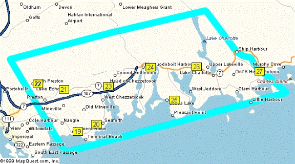
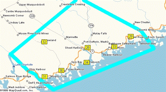
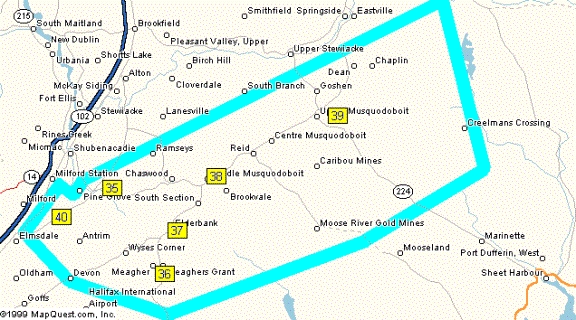
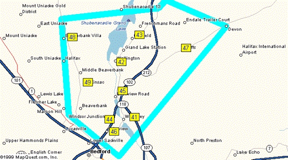
MAPS
1. Maps created by Stephen:
| General Map | Core Area |
Rural Zone 1
West part of Eastern Shore |
Rural Zone 2 East Part of Eastern Shore |
Rural Zone 3 Musquodoboit Valley |
Rural Zone 4 Beaver Bank -Airport |
Western Region |
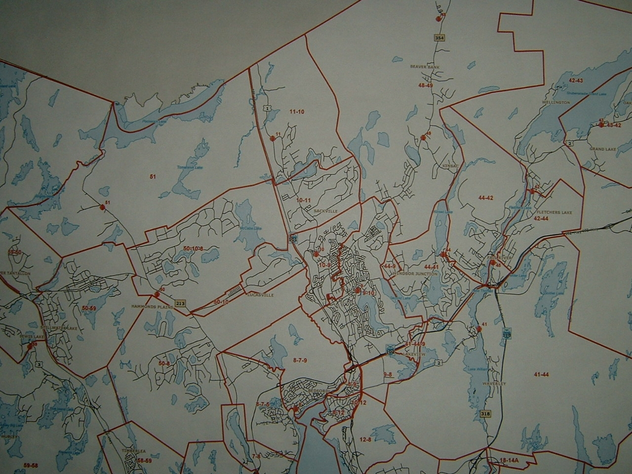
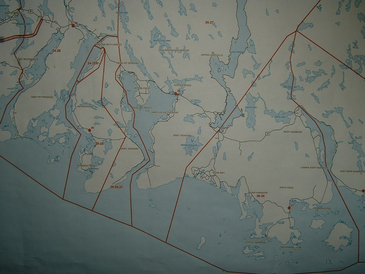
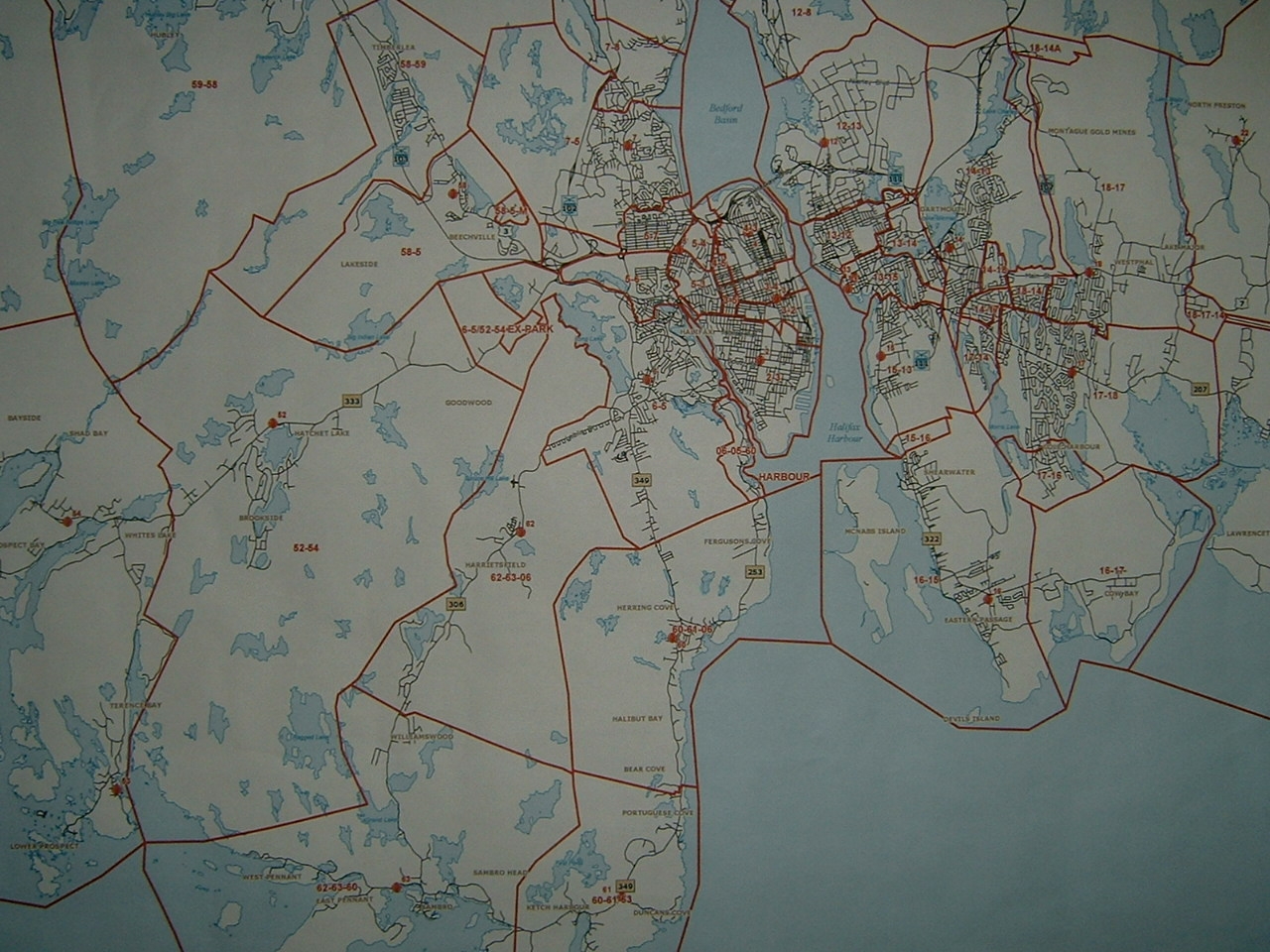
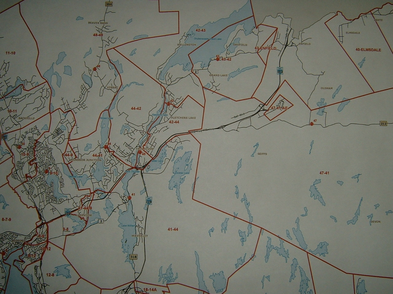
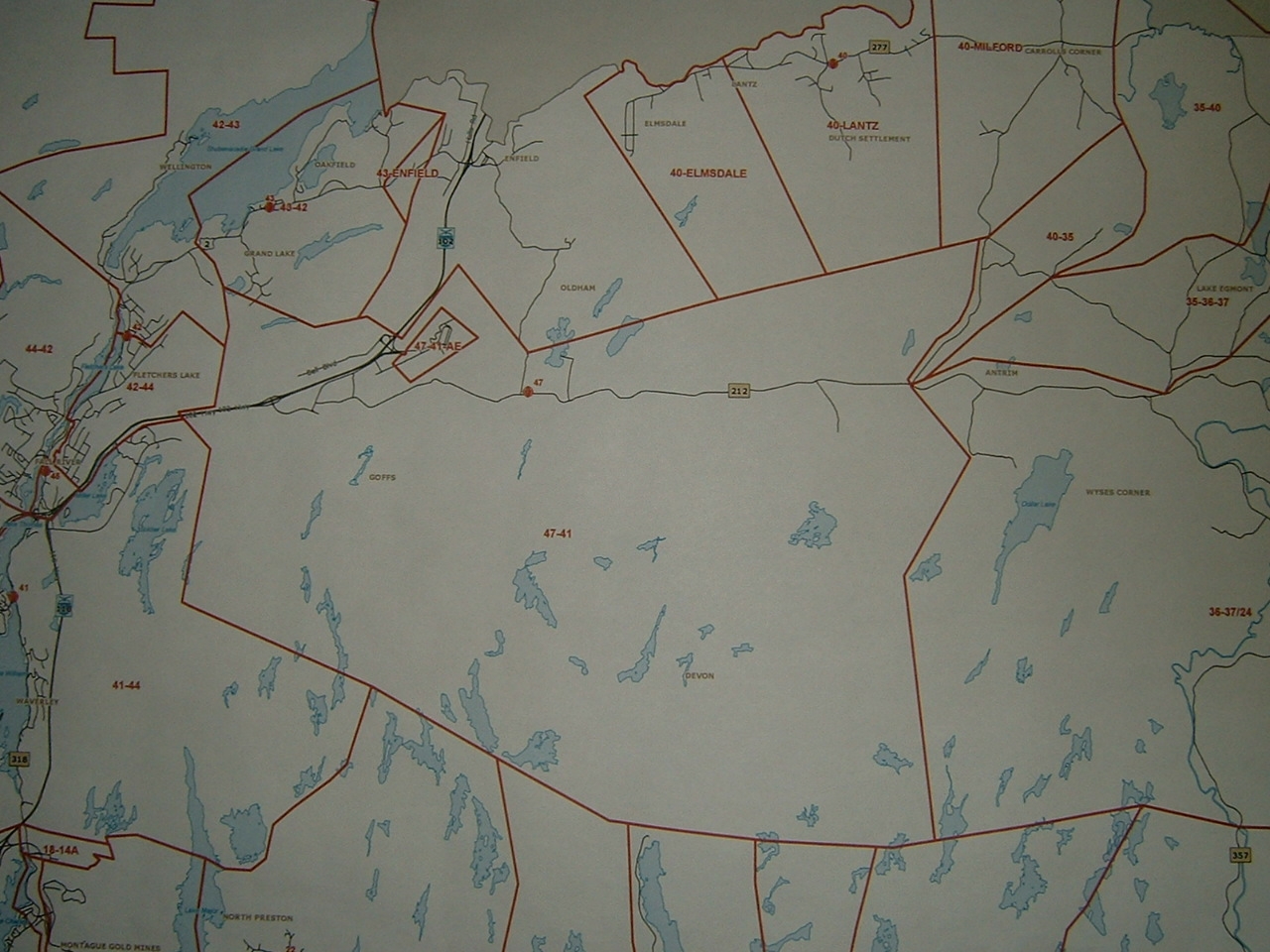
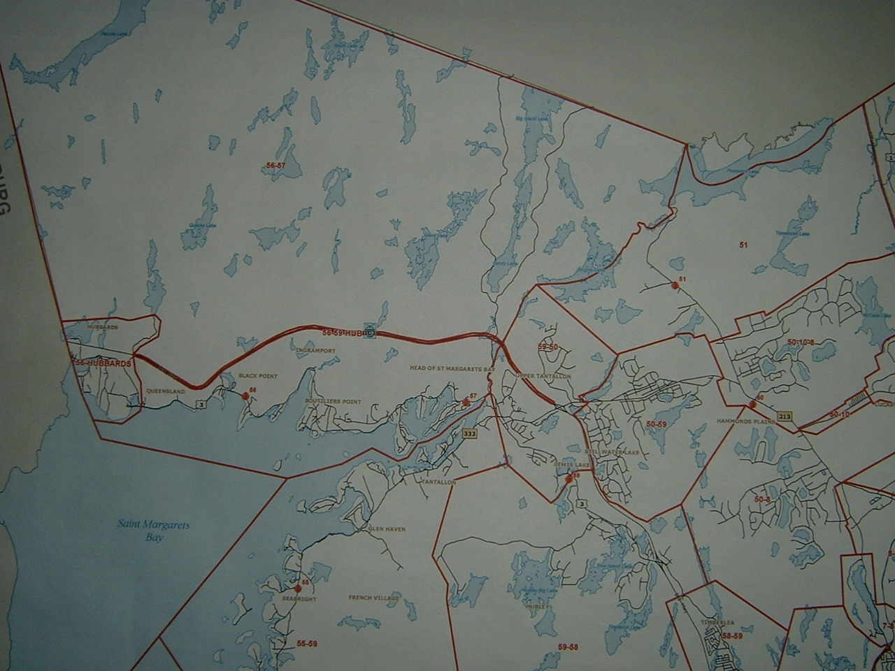
2. Excerpts from official response map.
The following photos are segments of the large HRFE map showing the response areas for each station. Each area outlined in red has one to three station numbers... this being the primary station, the first backup station, and perhaps an additional station. This indicates the order of response for dispatch purposes. Where a location is mentioned rather than a station number, this refers to a non-HRFE station. Unfortunately I do not have complete coverage, with the worst gap being in the interior east end of HRM. Photo geographical descriptions are very approximate and are not listed in any particular order. These photos of an actual official response map were taken in approximately 2006.
Herring Cove to Porters Lake Hammonds Plains to Grand Lake Musquodoboit Hbr to Ship Hbr Prospect to Cow Bay
Sackville to Waverley Sheet Harbour to Ecum Secum Waverley to Wyses Corner West End of HRM
Communications
Two way communications are carried out on the 800 MHz TMR. Radios have the following channel lineup which includes trunk system talk groups and conventional 800 frequencies. Originally the core stations used the A bank, with the rural units using the B bank. Beginning in 2012 all HRFE stations began using the A bank only, except in unusual circumstances. Non-HRFE stations paged by the IES continue to use the B bank. Note that there are seven operations talk groups in each of Banks A and B. There were also in the past OPS8-C and OPS8-R but earlier reconfigurations squeezed those out due to lack of space on the radios.
Conventional (non-trunk) channels are shown in this colour. BU repeaters are for use in the event of trunk failure and might also be used by other municipal departments. Conventional backup repeaters are installed at each of the TMR sites that serve HRM. Repeaters with the same frequency have differing CTCSS tone access. It is thought or suspected that the core area bu rptrs use 156.7 and most rural bank rptrs use 173.8, with Tangier and Chaswood using 192.8.
Vehicular repeaters are not actually known to be in use, and perhaps are not even installed.
C Bank is used very infrequently, and apart from the vehicular repeaters, is mostly for liaison with other agencies. Previously there were separate MECLOG, FIREPREV and TRNG talk groups but now all have been consolidated into SUPPORT on the previous MECLOG id.
| # | A Bank | B Bank | C Bank |
| 1 | DISP-C 14704 |
DISP-R 6416 |
SUPPORT 15120 |
| 2 | OPS2-C 14736 |
OPS2-R 6448 |
VR2 |
| 3 | OPS3-C 14768 |
OPS3-R 6480 |
VR3 |
| 4 | OPS4-C 14800 |
OPS4-R 6512 |
VR4 |
| 5 | OPS5-C 14832 |
OPS5-R 11984 |
VR5 |
| 6 | OPS6-C 14864 |
OPS6-R 12016 |
VR6 |
| 7 | OPS7-C 14896 |
OPS7-R 12048 |
MA-1 40080 |
| 8 |
PROSPECT BU RPTR 866.6125 MHz |
SHUBENACADIE BU RPTR 866.6125 MHz |
MA-2 40112 |
| 9 |
TANTALLON BU RPTR 867.1125 MHz |
CHAPLIN BU RPTR 867.1125 MHz |
MA-3 40144 |
| 10 |
SACKVILLE BU RPTR 867.6125 MHz |
MARINETTE BU RPTR 867.6125 MHz |
MA-4 40176 |
| 11 |
PRESTON BU RPTR 868.1125 MHz |
ECUM
SECUM BU RPTR 868.1125 MHz |
MA-5 40208 |
| 12 |
MARITIME CTR BU RPTR 866.4750 MHz |
MUSQUODOBOIT HBR BU RPTR 868.6125 MHz |
MA-6 40240 |
| 13 |
QUEENSLAND BU RPTR 868.6125 MHz |
TANGIER BU RPTR 866.6125 MHz |
HRM-1 14960 |
| 14 |
PNS VFDSIM 866.8125 MHz |
CHASWOOD BU RPTR 868.1125 MHz |
HRM-2 14992 |
| 15 |
PNS SXALL1 866.0125 MHz |
HRM
SIMPLEX-1 866.9625 MHz |
PNS
AMTSIM 867.0625 MHz |
|
16 |
PNS
SXALL2 866.5125 MHz |
HRM
SIMPLEX-2 867.4625 MHz |
PNS
AMTAIR 36112 |
The following is the sequence of events or protocol for use of talk groups
Dispatch pages out stations on the VHF system. For core area calls the working ops channel (talk group) will be indicated. This will be OPS2-C by default, or progressively higher C channels if calls are already in progress. Responding units will reply to dispatch on that assigned talk group and will continue to use it until the incident is over. For rural area calls no talk group is initially assigned. Responding units will reply on DISP-C. A working talk group will only be assigned once sufficient personnel have arrived on scene to actually commence the investigation and response. At that time OPS2-C or higher will be assigned. All communications from mobile units on DISP-C are rebroadcast on the rural VHF paging network. This allows volunteers to hear the progress of the response on their pagers. Once the responding units reach the scene and they switch to a working channel, the volunteers will no longer hear what is happening.
When an incident is over and command terminated units returning to station will go to DISP-C and will report when back in quarters.
Units on driver training and other non-incident tasks will be on DISP-C.
The two non-HRFE stations at Enfield and Mount Uniacke are paged on VHF similar to rural HRFE stations, except that they go to DISP-R. Once on scene the dispatcher will assign them to an R operations talk group. Generally Enfield is assigned to OPS2-R, and Mount Uniacke to perhaps OPS3-R.
DISP-R is patched to DISP-C so that in any area where DISP-R is affiliated, the traffic on DISP-C can be heard routinely over the DISP-R channel. This is most common around Enfield and Mount Uniacke and listeners outside of those areas should not normally hear any activity on DISP-R, due to the fact that most stations in HRM do not use that channel or indeed any R channel unless there are so many multiple incidents that use of that bank is required.
OPS5-R has apparently been assigned as a patch between HRFE and the Halifax Airport fire department. That department uses 400 MHz MotoTrbo and a link is necessary in case of mutual aid situations. This link is not continuously in operation, so in normal circumstances you will not hear airport fire by scanning OPS5-R. It has been reported that the link is tested at least weekly, but you must be in an area where OPS5-R is actually affiliated, which should only be on sites near the airport unless someone elsewhere actually tunes in a fire radio to monitor the test.
Further note re vehicular repeaters:
VR (Vehicle Repeaters) As of September 2006 it is not known if these have been instituted at all in HRFE. It is thought that 8 frequency pairs were set aside for this use, but only five VR spots are now on the chart. VR's are intended to extend portable communications, such as from within a fire scene, to the ops channel in use. For example it is thought that VR2 would be used if OPS2 was designated at a particular incident. Transmissions on VR2 from within the building would be repeated by a truck radio on the OPS2 talkgroup. These details may be erroneous, because there are 6 OPS talkgroups for each of rural and core areas, for a total of 12 (they would not use the DISP tg's) and only five VR's listed. The 8 set-aside frequencies were as follows (outputs only shown, in ascending order): VR1 867.9750, VR6 867.9875, VR2 868.4625, VR3 868.4750, VR4 868.4875, VR5 868.9625, VR4 868.9750, VR 7 868.9875 MHz. It is not known which of these have been retained in the five VR plan. The designations VR2 to VR6 on this chart may be obsolete, but on the other hand the five remaining VR may have retained old designations and frequencies shown above.