BILL'S NOVA SCOTIA RADIO SITE
FIRE DEPARTMENTS ON THE SOUTH SHORE
LUNENBURG, QUEENS, SHELBURNE AND YARMOUTH COUNTIES
Last updated March 26, 2013, with thanks principally to Doug, with input from Nick and Al, and others.
April 2011: This page has been consolidated from other pages and may be outdated or require other corrections. Please email or post on ScanMaritimes any suggestions or changes based on actual observation.'
The fire departments in this region do not use any coordinated system with integrated frequency usage as is used in Hants and Colchester counties; however as in other areas there is mutual aid using the standard 153.83 MHz mutual aid frequency, and some departments have the frequencies of adjacent departments in their radios. Many departments use the NS provincial IMRS repeater system which has the following sites in the region:
| Sherwood (Lunenburg County) | 152.210 MHz |
| Liverpool (Queens County) | 152.030 MHz, |
| Springfield (Queens County (inland) | 151.925 MHz |
| Middle Ohio (Shelburne County) | 151.535 MHz |
| East Kemptville (Yarmouth County) | 151.745 MHz |
| The following IMRS repeaters are scheduled to go into operation in 2013. Unlike all other IMRS repeaters, the West Queens installation is on a private tower. These repeaters are thought to be going into operation only with stated intent to use by local fire departments. | |
| West Caledonia CTV Tower (Queens) | 153.56 MHz |
| Italy Cross (Lunenburg County) | 152.27 MHz |
Some
departments use IMRS as the primary means of communications or for paging.
For more information
on the NS IMRS fire grid, click
here.
In addition to any other frequencies listed here, all fire departments in Nova
Scotia are thought to be capable of operating on the TMR (NS Trunked Mobile
Radio System) with at least one or two seeded radios. In general
TMR, if used at all, is used for administrative liaison with other departments, for use in
inter-agency mutual aid situations, for MFR liaison with ambulance dispatch, and
for backup contact with their own dispatch service. For the
most part these communications are on standard talk groups but some departments
are known to have their own private use talk groups that are thought to be used
in contact with their dispatch service or for communications between the holders
of the TMR radios.
Paging in this part of Nova Scotia is almost entirely carried out by third party providers. In Yarmouth County it is Yarmouth Control. In Lunenburg, Queens and Shelburne it is mostly provided by Scotia Business Centre in Bridgewater. Dispatch providers are indicated in the chart.
Paging and communications from and to the paging providers is done via different methods:
Phone line dial-up to activate pager. This is indicated on the charts as DUE (Dial up encoder)
Direct VHF on-air via repeater, i.e. dispatch is like any other unit working through the repeater. Dispatch centre is close enough for direct access.
Indirect on-air repeater and/or pager access, i.e. there is an intervening VHF or UHF link.
1. YARMOUTH COUNTY
Yarmouth County is made up of two rural municipalities as well as the independent town of Yarmouth. It is thought that all or most of these departments are dispatched by Yarmouth Control, but it is possible that some are dispatched by Scotia Business Centre.
This chart is tentative, both in completeness and accuracy, as it comes from two different sources, several years apart. Corrections, confirmations and updates are needed.
| County | Area | Community | Frequencies | Dispatch |
| Argyle Dist. | East Kemptville | 153.92, 154.070, 153.500 via 453.6125 Yarmouth/South Ohio Link and East Kemptville IMRS | Yarmouth | |
| Yarmouth | Argyle Dist. | East Pubnico | 154.265, 153.500 via 453.6125 Yarmouth/South Ohio Link and East Kemptville IMRS | Yarmouth |
| Yarmouth | Argyle Dist. | Eel Brook | 153.980, 153.500 via 453.6125 Yarmouth/South Ohio Link and East Kemptville IMRS | Yarmouth |
| Yarmouth | Argyle Dist. | West Pubnico | 153.425, and 151.745 East Kemptville IMRS | Yarmouth |
| Yarmouth | Argyle Dist. | Amiraults Hill/Hubbards Pt | 153.920, 150.275 Sx, and East Kemptville IMRS | Yarmouth |
| Yarmouth | Argyle Dist. | Lake Vaughan (Belleville) | 153.890, 153.500 via 453.6125 Yarmouth/South Ohio Link and East Kemptville IMRS | Yarmouth |
| Yarmouth | Argyle Dist. | Wedgeport-Plymouth | 154.280, poss 151.16, and 151.745 East Kemptville IMRS | Yarmouth |
| Yarmouth | Yarmouth Dist. | Carleton | 153.905 | Yarmouth |
| Yarmouth | Yarmouth Dist. | Quinan | 154.385, 153.500 via 453.6125 Yarmouth/South Ohio Link and East Kemptville IMRS | Yarmouth |
| Yarmouth | Yarmouth Dist. | Port Maitland | 154.310 | Yarmouth |
| Yarmouth | Yarmouth Dist. | Valley & Dist (Deerfield) | 155.265 | Yarmouth |
| Yarmouth | Yarmouth Dist. | Lakes & Dist (Lk George) | 153.410 | Yarmouth |
| Little River | 153.500 via 453.6125 Yarmouth/South Ohio Link and East Kemptville IMRS | Yarmouth | ||
| Yarmouth | Yarmouth Dist. | Islands & Dist (Surettes I) | 153.875,153.500 via 453.6125 Yarmouth/South Ohio Link and East Kemptville IMRS | Yarmouth |
| South Ohio | 153.500 via 453.6125 Yarmouth/South Ohio Link and East Kemptville IMRS | Yarmouth | ||
| Yarmouth | Town | Yarmouth | 154.430 | Yarmouth |
| County | Area | Community | Freq | Dispatch |
| Shelburne | Barrington Dist. | Barrington | 153.785 | Yarmouth |
| Shelburne | Barrington Dist. | Island & Barrington Passage/SouthSide/Clark's Hbr | 151.220, 153.200, 154.040 | Yarmouth |
| Shelburne | Barrington Dist. | Port Latour | 153.140 | Yarmouth |
| Shelburne | Barrington Dist. | Shag Harbour | 154.130 | Yarmouth |
| Shelburne | Barrington Dist. | Woods Harbour | 154.650 | Yarmouth |
| Shelburne | Shelburne Dist. | CGC (Churchover Gunning Cove) | 151.040 (154.04?) | Scotia |
| Shelburne | Shelburne Dist. | Ingomar/Roseway | 153.515 | Scotia |
| Shelburne | Shelburne Dist. | Jordan Falls | 152.375 | Scotia |
| Shelburne | Shelburne Dist. | Middle/Upper Ohio | 150.725 | Yarmouth |
| Shelburne | Shelburne Dist. | Harbour (NE & NW) | 151.295 | Scotia |
| Shelburne | Shelburne Dist. | Port Clyde | 153.380 | Yarmouth |
| Shelburne | Shelburne Dist. | Sable River/Little Hbr | 152.105 | Scotia |
| Shelburne | Shelburne Dist. | Little Harbour | 153.320 | Scotia |
| Shelburne | Town | Lockeport | 153.320 | Scotia |
| Shelburne | Town | Shelburne | 154.010 | Yarmouth |
3. QUEENS COUNTY Queens County is entirely occupied by the Queens Regional Municipality which was an amalgamation of the Queens Rural Municipality and the independent towns lying within it. Unlike the Cape Breton Regional Municipality and the Halifax Regional Municipality, the fire services in QRM have not yet been unified and therefore these departments operate as before, i.e. independently except in cases of mutual aid. While the departments generally have their own operating frequencies, all can use the IMRS repeater system. Most would access the Liverpool repeater on 152.030 MHz but the northern (inland) areas might more normally use the Springfield repeater on 151.925 MHz.
| AREA | AREA | COMMUNITY | FREQ | DISPATCH |
| Queens | Queens RM | Greenfield | 154.620 | VALLEY DISPATCH |
| Queens | Queens RM | Liverpool | 154.310 | VALLEY DISPATCH |
| Queens | Queens RM | North Queens | 154.190 | VALLEY DISPATCH |
| Queens | Queens RM | Mill Village | 152.315 | VALLEY DISPATCH |
| Queens | Queens RM | Charleston | 155.520 | ??? |
| Queens | Queens RM | Port Medway | 153.785 | VALLEY DISPATCH |
| Queens | Queens rm | *Queens First Responders (Port Mouton) | 153.860 | VALLEY DISPATCH |
*This is a medical response team, not for firefighting
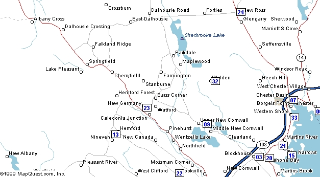
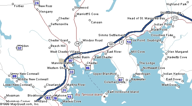
4. LUNENBURG COUNTY Lunenburg County is made up of two separate rural municipalities: Lunenburg and Chester, and as well contains a number of independent towns. Fire departments in Lunenburg County do not yet have a unified communications and paging system, and are therefore essentially separate from each other, except when in mutual aid. Departments can and in some cases regularly do use the IMRS repeater system, with most accessing the Sherwood repeater on 152.21 MHz, but some of the more southwesterly departments might more regularly use the Liverpool repeater. There is a chance that inland (northwest) areas might access the Springfield repeater on 151.925 MHz.
The following maps are courtesy of Stephen. Station numbers on the maps are also on the chart following.
![]() |
![]() |
![]() |
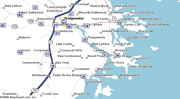
The vast majority of departments in Lunenburg County are paged by Scotia Business Ctr in Bridgewater, through a variety of transmitters. The exceptions are New Ross which is paged by Valley Dispatch in Kentville, and Bridgewater which pages itself.
Scotia Business Ctr has a paging transmitter at Newcombville on 153.26 MHz, used by several departments and another listed for 167.1 at Oakhill.
In the chart below, in the frequency column if there is a pair separated by a slash, this indicates a repeater pair with the repeater output appearing first, unless there is a an asterisk which is intended to indicate that I do not know which of the two frequencies is the output, and which is the input. Sx stands for simplex
|
# |
Map |
NAME |
Page Time (can vary) |
PAGE |
frequency |
CTCSS |
|
01 |
S |
BAKER’S SETTLEMENT |
1847 |
153.260 |
151.760 |
100.0 |
|
02 |
East |
BLANDFORD |
153.260 |
153.620 |
|
|
|
03 |
East |
BLOCKHOUSE |
1820 |
153.800 |
153.800 |
|
|
04 |
S |
|
1800 |
154.340 |
154.340 |
|
|
05 |
S |
|
1855 |
153.260 |
154.635 |
100.0 |
|
06 |
East |
|
1802 |
153.440 |
153.440 |
|
|
07 |
East |
|
1801 |
153.935 |
153.935 |
|
|
08 |
S |
CONQUERALL BANK |
2000 |
153.980 |
153.980 |
142.6 |
|
09 |
East |
|
1806 |
155.265 |
155.265 |
|
|
10 |
S |
DAYSPRING |
1815 |
153.26/154.325 |
154.325 |
|
|
11 |
S |
HEBB’S CROSS |
1750 |
153.260 |
151.325 |
100.0 |
|
12 |
S |
HEBBVILLE |
1731 |
154.430 |
154.430 |
173.8 |
|
13 |
North |
HEMFORD |
153.200 |
153.200 |
|
|
|
14 |
East |
HUBBARDS |
1830 |
154.25 |
154.25/159.825 |
|
|
15 |
East |
INDIAN POINT |
? |
159.135 |
|
|
|
16 |
S |
|
153.425 |
153.425 |
|
|
|
17 |
S |
LAHAVE |
1745 |
153.770 |
153.770 |
114.8 |
|
18 |
S |
|
1825 |
153.260 |
150.950 |
100.0 |
|
19 |
S |
LUNENBURG |
1731 |
153.875 |
153.875 |
71.9 |
|
20 |
East |
|
1730 |
154.710 |
154.710 |
123.0 |
|
21 |
East |
|
1830 |
159.650 |
154.650 |
|
|
22 |
S |
MIDVILLE BRANCH |
1725 |
153.260 |
153.920 |
100.0 |
|
23 |
North |
NEW |
1830 |
154.055 |
154.055 |
|
|
24 |
East |
NEW ROSS |
1905 |
153.905? |
152.330/157.905 |
|
|
25 |
S |
NEWCOMBVILLE |
1730/1846 |
153.260 |
155.295 |
100.0 |
|
26 |
S |
|
1820 |
151.145 |
151.145 |
|
|
27 |
North |
OAKHILL |
1831 |
167.100 |
151.295 |
|
|
28 |
S |
PETITE RIVIERE |
1900 |
153.200 |
152.705/158.280 |
DCS 023 |
|
29 |
S |
PLEASANTVILLE |
1835 |
151.490 |
151.490 |
100.0 |
|
30 |
S |
RIVERPORT |
1755 |
154.085 |
154.085 |
100.0 |
|
31 |
North |
UNITED COMMUNITIES |
1810 |
151.07 |
151.145 Sx |
|
|
32 |
East |
WALDEN |
1830 |
154.555 |
154.555 |
|
|
33 |
East |
|
1840 |
154.700 |
154.770 |
|
|
34 |
S |
WILEVILLE |
1845 |
153.260 |
154.295 |
100.0 |
CTCSS/DCS tone information may be incomplete and additions to them, or any other corrections are invited. Input frequencies are also requested.
This chart does not included Tancook Island First Responders. Information is sought on this organization.
Bridgewater FD is also reported to have in its radios: 152.27 (former McCarthy Towing), 169.425 Town Parks and Rec, 151.955 (Tac 2 and former Public Works), SCBA 154.57 simplex.